
8/3 Forecast
1. Pressure System
1. Surface Pressure


-
A high-pressure system forms south of the Korean Peninsula, bringing southerly to southwesterly winds.
-
By 21 KST, the peninsula enters the high-pressure zone with clear sky and stable conditions.
The North Pacific High expands, and the southern high moves north.
-
As a result, the Korean Peninsula mostly experiences clear sky.
2. 925hpa


-
The low-pressure system north of the Korean Peninsula is moving eastward and moving away.
A high-pressure system has formed over the peninsula, indicating the presence of a warm air flow.
-
At 21 KST, the 925 hPa geopotential height over the Korean Peninsula increased, with temperatures remaining high between 24 and 27°C. Meanwhile, the North Pacific High extended its influence westward.
3. 850hpa


-
Temperatures aloft over the Korean Peninsula show signs of slight moderation. As of 09 KST, most of the peninsula experiences temperatures between 18 and 21°C, with the eastern region seeing temperatures of 21 to 24°C.
-
A clockwise flow from the high-pressure system located south of the peninsula generates northwesterly winds.
-
The low-pressure system north of the peninsula has moved eastward and is expected to continue moving away, allowing the Korean peninsula to exit its influence.
2. Wind
850hpa Stream Line & Isotach


-
With a high pressure to the south and a low pressure to the north, winds generally flow from south to north over the Korean Peninsula.
Following the clockwise flow of the southern high, westerly to northwesterly winds dominate.
-
Though wind speeds remain weak, tighter streamlines compared to the 2nd indicate more organized airflow.
-
At 21 KST, a weak circulation appears southwest of the peninsula, signaling enhanced atmospheric stagnation.
3. Precipitation/ Humidity

Low possibility of precipitation overall
The Gyeongsang region is expected to have strong atmospheric instability due to convergence + wet layer+ low-layer jet presence + KI high.
01
850hPa Moisture Flux
-
Water flow from the south to the Korean Peninsula
-
Weak moisture zone only on the Gyeongsang
-
low possibility of precipitation development.
03
850hPa Streamline and Isotach
-
Strong wind formality with the inflow of southwest wind currents.
-
The region where the air currents converge is centered in the south, and a swirling rotation is also observed -> possibility of heavy rain
02
1000-500hPa Thickness & 700hPa T-Td
-
High temperature and humid tropical end influence zone with laminar thickening in the range of 5820-5880 gpm
-
Gyeongsang :possibility of precipitation
04
K-index
-
KI 30~ 38 levels across the Korean Peninsula → Slightly unstable to moderate overall.
-
K-Index 35-39 in south→ Atmospheric instability very high in southern regions, thunderstorm potential
4. Cloud

-
North-central Korean Peninsula (northeastern Gyeonggi and inland Gangwon):Low- to mid-level clouds are spread out → Possibility of light showers.
-
Chungcheong, Gyeongsang, and Jeju regions:Clouds appear clustered and then dispersing, suggesting localized convective clouds → Local showers are expected under otherwise relatively stable weather conditions.
5. Temperature
2024.08.03|09KST

As of 9 AM on August 3rd, following the dry adiabat line from the 850 hPa temperature on the thermodynamic chart down to the surface, the maximum temperature is expected to be approximately 32°C.
2024.08.02|21KST

As of 9 PM on August 2nd, the minimum temperature in Seoul on August 3rd is expected to be approximately 25°C.
8/3 Observation
1. Wind


2. Precipitation

Mostly sunny or temporary showers
South Gyeongsang, Jeju: 20 mm precipitation
3. Temperature

-
Daily average
→ All of South Korea is recording high temperatures around 30°C or higher
-
climate deviation
Almost the entire area is covered in pink, East Coast. Deep pink on the southern coast → Temperatures much higher than usual
Temperature deviations above +2,3°C in most areas and above +5°C in some areas
-
Standard score
Z-Score is 0.25, 0.5 or higher in most of the country
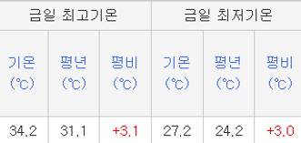
Maximum temperature is 34.2°C, 3.1°C above last year (31.1°C)
Minimum temperature is 27.2°C, 3.0°C above last year (24.2°C)