
Pressure System
The North Pacific High and Tibetan High simultaneously covered the Korean Peninsula, causing warm and stable air to stagnate in both upper and lower layers.
This dual high-pressure system pushed the upper jet stream northward,
maintaining clear skies and enhancing surface heating and radiant heat accumulation.
1. Pressure Systems and Heat Waves

Pressure systems are the fundamental factors that determine atmospheric flow, directly influencing air movement, precipitation, cloud formation, and the surface energy balance.
In summer, when high-pressure systems become stationary, descending air dominates, suppressing cloud formation and weakening winds, which leads to prolonged clear weather.
These atmospheric conditions create a structure where radiant heat accumulates at the surface and cannot dissipate, serving as a key background factor in the occurrence and intensification of heat waves.
2. North Pacific High and Tibetan High
North Pacific High Pressure
The North Pacific High is characterized by warm and humid maritime air masses, placing Korea under its influence during summer.
Through its clockwise circulation, it transports warm, moist air from the southern seas toward the Korean Peninsula, enhancing surface radiative heating.
In other words, the North Pacific High serves as a fundamental background condition for the formation of summer heat waves in Korea.
When this high-pressure system expands strongly, a broad high-pressure area extends from the Northwest Pacific to the Korean Peninsula.
Tibetan High Pressure
The Tibetan High is a hot and dry high-pressure system formed in the upper atmosphere due to strong heating of the Tibetan Plateau, intensifying summer heat waves.
During summer, the Tibetan Plateau is heated by intense solar radiation, leading to the formation of this high-pressure system in the upper atmosphere (500–200 hPa).
It induces descending airflows that suppress cloud formation and stabilize the atmosphere, creating conditions favorable for prolonged heat waves.
Together with the North Pacific High, it forms a stacked high-pressure structure known as a “heat dome,” which prolongs heat waves and tropical nights.
3. Expansion and stagnation of the high pressure
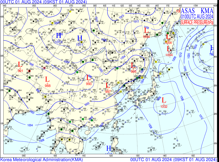
2024/08/01 ~ 2024/08/07
Surface Pressure
-
The center of the North Pacific High expanded without significant movement from the eastern sea of the Korean Peninsula.
-
Warm and humid southerly winds continued to flow into the peninsula following the clockwise circulation.
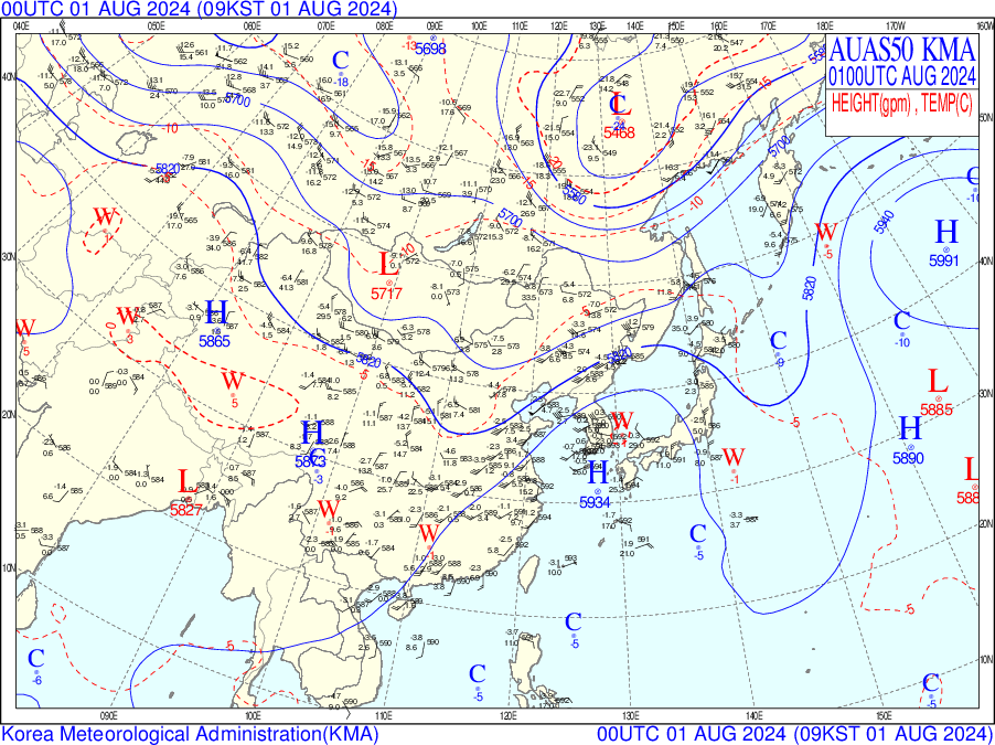
2024/08/01 ~ 2024/08/07
500hPa
-
From August 3rd to 4th, the Korean Peninsula was positioned under a ridge.
-
Within the ridge, descending air induces adiabatic compression, raising temperatures. It also suppresses cloud formation and accelerates radiative heating.
-
The Tibetan High expanded over the peninsula, strengthening the descending flow and further inhibiting cloud formation.
This also traps surface radiant heat, creating conditions that prolong heat waves and tropical nights.

The North Pacific High shifted northward beyond its average position, extending its influence near Korea.
Meanwhile, increased convection over northwestern India caused the Tibetan High to expand toward the northeast of Korea.
As a result, two high-pressure systems overlapped above Korea, creating warm and stable air layers both aloft and near the surface.
This formed a "heat dome," intensifying the heat wave.
IDV Analysis
Sea Level Pressure
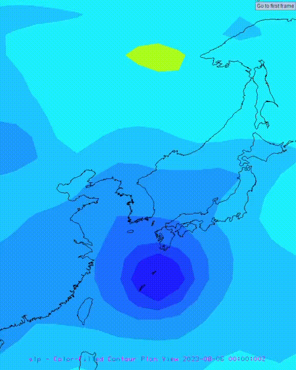
2023/08/01 ~ 2023/08/07
-
The high-pressure center is small and cut off, indicating a weak stagnant high-pressure system.
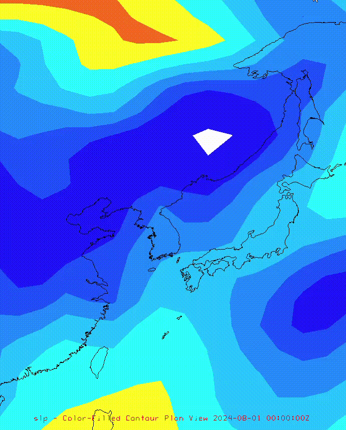
2024/08/01 ~ 2024/08/07
-
A strong and extensive high-pressure center is positioned over the seas southeast of the Korean Peninsula and south of Japan.
-
A strong high-pressure system is also located northeast of the Korean Peninsula.
-
The centers of these high-pressure systems remain nearly stationary near the Korean Peninsula and Japan for several days.
According to IDV data, compared to August 2023, the high-pressure system in August 2024 was stronger and more expansive, continuously bringing in warm and humid air.
Additionally, the descending airflow maintained clear skies, allowing radiant heat to accumulate and resulting in more severe heat waves and tropical nights.